To effectively mobilize your field crews and ensure fleet optimization to address community needs, you need the data and insight to understand and manage performance in real time. To capture this data, these teams can become data collection sensors as they feed critical location-based information to the back office for more informed decision-making and improved fleet management. In turn, your advanced insight will better guide field operations and fleets to where they are needed most and improve service quality.
Routing and navigation
Dynamic workforce management
Improved asset inventory
Optimize routing and navigation
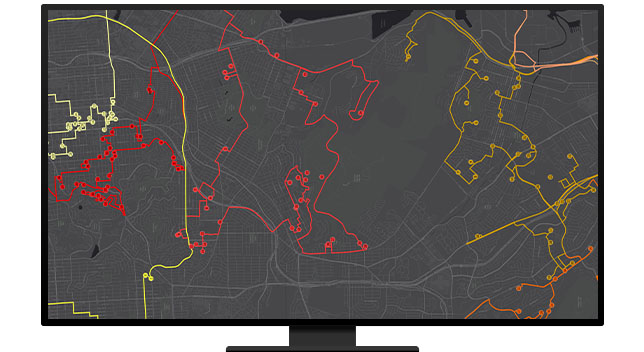
Productivity gains are significant when you optimize field operations and public works fleets through GIS. Optimized routes can help waste management, snowplow, and street-sweeping teams control costs like fuel and improve efficiency. Fleet managers can measure material use and performance through Internet of Things sensors to support real-time decision-making.
Achieve dynamic workforce management
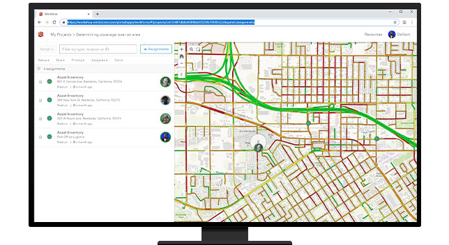
Use the power of location to coordinate your mobile workforce through prioritized work order management between the field and operations center. GIS provides a common geospatial view for inspections, fleet maintenance, asset tracking, asset management, and scheduled work with reduced errors, increased productivity, and cost savings.
Improve asset inventory
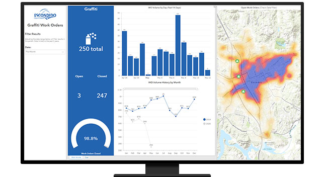
Collecting accurate asset data fuels long-range planning, maintenance, and budgeting. Field data collection tools support inventories ranging from trees to pavement conditions and street furniture to give you more detailed information. Citizen reporting apps allow people to report concerns and experience faster response times.
CASE STUDY
Hillsboro tracks sweeper location data with GIS
The city simplified its workflow of tracking path data from its street sweepers using GIS to meet stakeholder needs.
Read the case study
CASE STUDY
Keeping Emerald Isle clean by leveraging GIS
Despite facing a 1,000% increase in yard waste pickup requests during the summer, the city keeps up using GIS.
Read the case study
CASE STUDY
LANL embraces near real-time solutions with GIS
Los Alamos National Laboratory leverages a suite of GIS applications to keep roads clear of snow and keep employees safe.
Read the case study
CASE STUDY
DuPage County: Winter weather solutions
GIS-enabled snowplow operations allow DuPage County to plan the most efficient routes and visualize all streams of operation data using maps.
Read the case study
Products and ArcGIS Solutions
Explore ArcGIS Solutions and product offerings that enhance field and fleet management.
Explore more solutions
Apps for field operations
Improve coordination and operational efficiency in the field. Reduce errors and reliance on paper, boost productivity, and save money.
More on field operations
ArcGIS Velocity
Ingest data from the Internet of Things or third-party APIs in ArcGIS Online to monitor assets, predict maintenance, and optimize processes.
More on ArcGIS Velocity
ArcGIS Dashboards
Present data and analytics on an intuitive and interactive screen to visualize trends, monitor status in real time, and inform stakeholders.
More on ArcGIS Dashboards
ArcGIS Network Analyst
This ArcGIS extension provides the network-based spatial analysis tools to plan routes, calculate drive times, and locate facilities.
More on ArcGIS Network Analyst
ArcGIS GeoEvent Server
Gain situational awareness of real-time streaming data. Automatically update maps and databases and send alerts when thresholds are met.
More on ArcGIS GeoEvent Server
ROW Asset Inventory
Inventory signs, signals, streetlights, and other visible assets in the public right-of-way.
Explore this solution
Winter Weather Operations
Develop winter weather response plans, monitor winter weather operations, share road status updates, and track vehicle locations and materials.